
Clicking on a station location †to the right of the map will take you to a graph which shows snow pack conditions for the current water year for a single NRCS SNOTEL station. Graphs courtesy of the†Western Regional Climate Center.
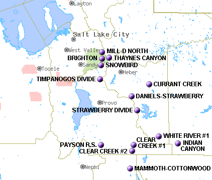 Station & Elevation
Mill-D North 8,960
Thaynes Canyon †9,200
Brighton †8,750
Cascade Mountain †7,768
Snowbird †9,640
Timpanogos Divide †8,140
Currant Creek †8,000
Daniels-Strawberry 8,000
Strawberry Divide 8,400
White River #1 8,550
Indian Canyon 9,100
Payson R.S. 8,050
Clear Creek #1 9,200
Clear Creek #2 8,300
Mammoth Cottonwood 8,800